The intersection of applied geophysics and ecological field survey is still young. Most wildlife surveyors working with GPR today came to the technology through necessity — a client needed to demonstrate non-destructive investigation of a protected species habitat, or a planning authority required evidence of subsurface features before a development could proceed. The tools existed; what was missing was the interpretive expertise to use them confidently.
That gap is closing rapidly. As GPR systems become more portable, more intuitive to operate in the field, and less expensive to deploy, the technology is moving from specialist geophysical contracts into the standard toolkit of environmental and ecological consultancy. Understanding what GPR can and cannot deliver in this context — and what separates a defensible interpretation from a guess — has never been more important.
Key notes
Ground Penetrating Radar was built for engineering and geology. But in the last decade, ecologists, wildlife surveyors, and environmental consultants have discovered something the geophysics community has long known: if it’s underground and different from the surrounding material, GPR will find it.
The Core Problem: What Lies Beneath Protected Habitats
Wildlife legislation across the UK and Europe imposes significant constraints on ground investigations near protected species habitats. Destructive methods — trenching, probing, core sampling — may be prohibited entirely, or may require licensing that adds cost and time to a project. The result is a growing demand for non-invasive subsurface characterisation: a way to understand what is underground without disturbing it.
For many of the most commonly encountered protected species, the ecological question is fundamentally a subsurface one. Badgers excavate complex tunnel networks and chamber systems that extend metres beyond the visible sett entrance. Otters construct holts within riverbank root systems at depths that vary with water table and bank composition. Reptiles overwinter in existing burrows and features at shallow depth. Great crested newts use subterranean refugia during periods of terrestrial activity. In each case, the critical evidence — the extent, depth, complexity, and active use of a subsurface habitat feature — lies out of sight.
Visual survey methods can identify surface indicators — disturbed soil, worn vegetation, characteristic latrines, entrance morphology — but they cannot characterise the subsurface extent of a feature with any precision. Thermal imaging can detect heat signatures associated with active occupation, but is confined to the surface or entrance zone. Endoscopy requires access to a tunnel entrance and gives a narrow, positional view. None of these methods answers the question that planning authorities, habitat management teams, and development ecologists most frequently need answered: how far does this feature extend, how deep is it, and how structurally complex is it?
Visual survey methods can identify surface indicators — disturbed soil, worn vegetation, characteristic latrines, entrance morphology — but they cannot characterise the subsurface extent of a feature with any precision. Thermal imaging can detect heat signatures associated with active occupation, but is confined to the surface or entrance zone. Endoscopy requires access to a tunnel entrance and gives a narrow, positional view. None of these methods answers the question that planning authorities, habitat management teams, and development ecologists most frequently need answered: how far does this feature extend, how deep is it, and how structurally complex is it?
What GPR act
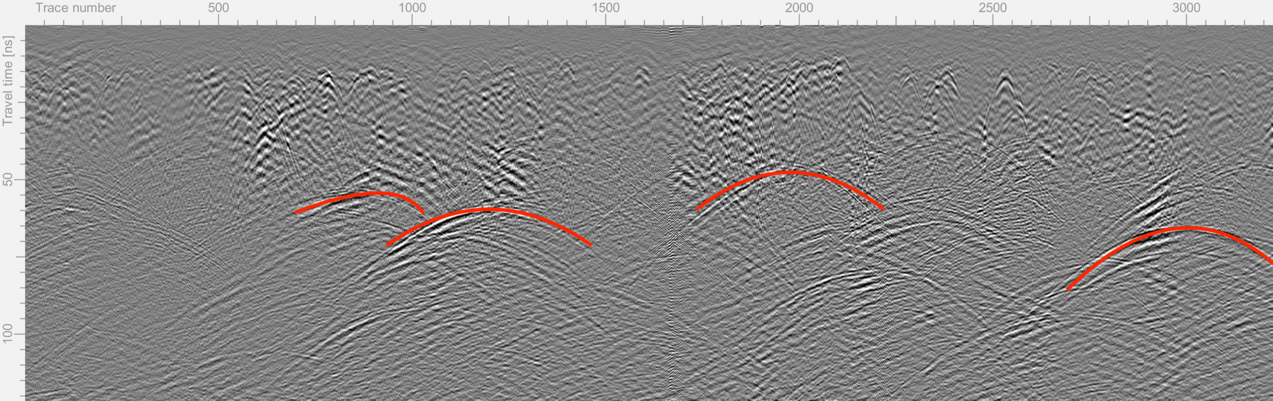
The critical diagnostic signature for a tunnel or burrow in GPR data is the hyperbolic diffraction. As the antenna travels along the surface, it begins to detect a cylindrical void before it is directly overhead, reaches minimum travel time directly above it, and continues detecting it as the antenna passes. The resulting pattern on the radargram — a symmetrical arch opening upward — is the fingerprint of a discrete subsurface void. Its apex gives the depth; its curvature gives information about the propagation velocity of the surrounding soil; its amplitude tells us about the dielectric contrast between the void and its host.
For ecological applications, this is significant: an air-filled tunnel in moist soil represents one of the highest dielectric contrasts available to GPR. In favourable conditions, badger tunnels, otter holts, and similar features are among the strongest reflectors a GPR system will encounter. The physics is on our side.

Species Applications: Where GPR Has Proven Value
GPR has now been applied across a range of protected species survey contexts. The depth and complexity of interpretation required varies considerably between applications, but the underlying diagnostic method is consistent.
01
Badger
The most established ecological GPR application. Badger setts consist of tunnel networks at 0.3–1.0 m depth, often with multiple runs radiating from central chambers. GPR can characterise tunnel extent, identify chamber locations through elevated amplitude responses, distinguish active from partially collapsed runs, and detect oblique tunnel orientations through diffraction geometry. Full sett mapping in advance of development enables proportionate and defensible mitigation planning.
02
Otter
Otter holts within riverbank systems are typically shallower and more structurally variable than badger setts, often utilising existing root voids rather than self-excavated tunnels. Survey requires careful discrimination between root system diffraction patterns and genuine holt cavities — a task that benefits from expert processing. Particular value in pre-works assessment where bank reinforcement or bridge works are planned.
03
Water Vole
Water vole burrow systems are shallower (typically 0.1–0.3 m) and smaller in diameter than badger tunnels, placing them at the resolution limit of standard antenna frequencies. Higher-frequency systems (400 MHz and above) are generally required. GPR can contribute to burrow system mapping along bank transects, particularly where multiple colony areas require extent characterisation prior to habitat management.
04
Reptiles
Reptile hibernacula — subterranean overwintering refugia — typically occupy existing features such as old mammal burrows, tree root voids, and shallow soil cavities. GPR survey of suspected hibernacula sites can help characterise the subsurface feature density and depth distribution, informing both the hibernation potential assessment and translocation receptor site selection.
05
Great Crested Newt
GCN terrestrial habitat assessment is increasingly incorporating subsurface characterisation to understand refugia availability and connectivity. While individual newt burrows are below GPR resolution, feature mapping of existing subsurface voids within key terrestrial habitat zones contributes to habitat quality assessment and post-mitigation monitoring frameworks.
A journey commenced, starting cheerfully under a clear sky, and a tranquil sea.
GPR data acquisition is a skill that can be learned relatively quickly by a competent field surveyor. The Leica DS4000, the GSSI SIR series, MALÅ ground-coupled systems, and similar instruments used by ecological consultancies today are well-engineered, robust, and increasingly user-friendly in the field. Collecting a grid of swaths over a suspected sett is a tractable task for a trained operator.
Where expertise becomes non-negotiable is in the post-processing and interpretation stage. Raw GPR data contains the signal of interest embedded within a mixture of antenna ringing, surface-coupled noise, background clutter from roots and stones, geometric spreading effects, and — in active sett areas — the complex overlapping diffractions of multiple closely-spaced features. Extracting a defensible interpretation from this requires both technical processing and physical understanding.
What specialist processing involves
A professional GPR processing workflow for ecological data typically includes time-zero correction to establish a consistent surface reference; dewow filtering to remove low-frequency DC drift from the antenna wavelet; bandpass filtering matched to the antenna frequency to suppress out-of-band noise; background removal to suppress horizontally coherent ringing; and gain application to compensate for geometric spreading with depth. Each of these steps involves parameter choices that affect the final output — and applying them consistently across a multi-swath dataset is essential for comparative interpretation.
But processing is only the first step. The interpretive challenge — distinguishing genuine tunnel signatures from root diffractions, identifying nested features indicative of complex sett architecture, recognising the asymmetric geometry produced by obliquely-oriented tunnels, flagging metallic artefacts that mimic subsurface features — requires experience that cannot be automated. A standard processing package will identify obvious hyperbolas; it will not tell you whether two overlapping diffractions indicate two tunnels or one tunnel with internal structure, or whether a single-arm dipping event represents an oblique run or a dipping geological boundary.