Advancements in ground penetrating radar (GPR) hardware have dramatically increased the resolution and depth penetration capabilities available to geophysicists and survey professionals. Today’s state-of-the-art GPR systems produce cleaner, higher-definition images of the subsurface than ever before, instilling a sense of confidence among users.
However, these technical improvements have not been matched by equivalent progress in the interpretation processes. As a result, misinterpretations continue to impede the accurate understanding of subsurface features. This article examines the gap between improved hardware performance and the persistent challenges of data interpretation. It illustrates how even the most refined radargrams can be misread without rigorous analytical approaches, proper training, and a healthy skepticism toward seemingly straightforward results.
By exploring real-world examples—from cemetery surveys that initially misidentified hyperbolic patterns to utility mapping projects that suffered severe operational setbacks —we highlight the importance of continually evolving interpretation practices to keep pace with technological progress.
The Illusion of Confidence in GPR Data Interpretation
The enhanced clarity provided by modern GPR systems often creates an illusion of complete certainty in data interpretation. With improved signal quality and processing software that promises near real-time imaging, users can become over-reliant on default settings and automated processing routines. This confidence is bolstered by the ability to quickly generate “pretty” radargrams that appear to delineate subsurface layers and objects with good precision.
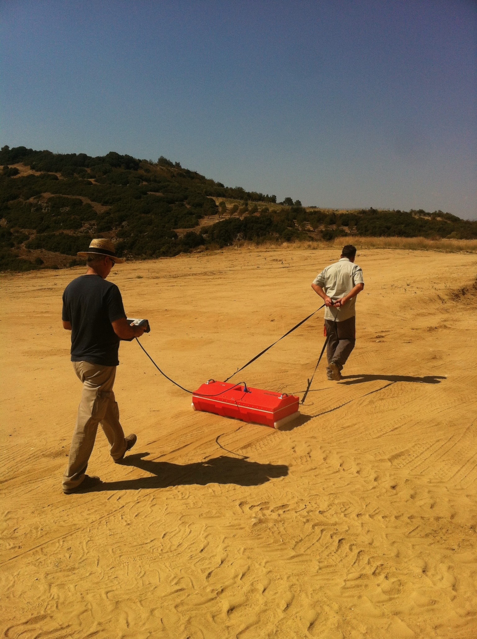
For example, enhanced radar outputs may lead users to assume that hyperbolic reflections directly indicate the presence of buried objects. See the picture below; this data was collected in Cyprus and operators observed hyperbolic responses in the GPR line data (red frame) and initially presumed each curve represented a utility. Only after generating depth slices through a grid of data lines did it become apparent that the hyperbolas were responses from a scattering layer—rather than the utilities themselves. This example underscores the risk of adopting an overly simplistic interpretation: even clear images can conceal underlying complexities if not critically re-examined through alternative processing and cross-sectional analysis.
Furthermore, reliance on automated processing tools can inadvertently encourage analysts to accept default software outputs without robust verification measures. While advanced algorithms such as the Hilbert transform or F–K filtering can improve the resolution of features, these techniques still require careful human interpretation to distinguish genuine anomalies from noise artifacts. The problem arises when confidence in the hardware and accompanying software overshadows the necessity for expert judgment, leading to decisions based on what appears to be unequivocal data—but may in fact be misinterpreted signals.

Common Interpretation Shortcuts and Pitfalls
Despite the significant technical strides in GPR hardware, several common pitfalls in data interpretation persist, often resulting in costly mistakes. A major shortcut is the dependence on minimal processing procedures. Many surveyors may not adjust gain settings, time-zero corrections, or other signal enhancements that are crucial for distinguishing relevant reflections from the background noise. This reliance on default processing, without tailoring the parameters to the specific survey conditions, is particularly dangerous when investigating environments where soil moisture, electromagnetic interference, or multiple overlapping subsurface layers exist. In utility mapping applications, for instance, failing to properly account for the variable depth of buried pipelines or the presence of recent infrastructure modifications has resulted in catastrophic operational failures, including gas explosions and water main ruptures.
Additionally, a troubling trend is the underestimation of uncertainty. Technicians may believe that improved image quality negates the possibility of error, disregarding the fact that every GPR survey carries inherent uncertainties—stemming from factors such as soil conductivity, dielectric constant selection, signal attenuation, and environmental noise. In practice, this can lead to a “confirmation bias” where analysts interpret data in a way that supports their initial assumptions. Such bias is dangerous, as it may prompt responders to ignore contradictory evidence that emerges from more detailed investigations or complementary data sources. This phenomenon is especially evident in cases where preliminary interpretations are not revisited after additional data collection reveals alternative explanations for observed features.
The comparison between traditional and modern approaches to data processing serves as a vivid illustration of these pitfalls. While early GPR techniques required an in-depth, manual review of each trace, modern systems have increasingly abstracted the process through real-time software enhancements. Nonetheless, this has not eliminated the need for expert interpretation. Instead, it has introduced new challenges: analysts must now sift through high-definition images and sophisticated output data while remaining vigilant against overconfidence caused by the apparent “cleanliness” of the data.
The Role of Experience in Effective GPR Interpretation
Experience remains an irreplaceable factor in the correct interpretation of GPR data. Even with the most advanced systems, the nuanced understanding gained through years of field work and continuous learning enables experienced geophysicists to recognize subtle indicators of error or misinterpretation that less experienced users might overlook. The ability to decipher complex radargrams, to adjust for local environmental factors, and to question initial interpretations is a skill that no automated system can fully replicate.
For example, seasoned interpreters are often aware of the potential for scattering artifacts, whether they arise from rough geological interfaces or from coarse-grained materials that create hyperbolic signatures in the radar data. They apply a rigorous methodology that involves iteratively adjusting processing parameters and cross-referencing results with historical or corroborative data. This iterative approach is a cornerstone of effective geophysical communication, as it ensures that every interpretation is supported by statistical and contextual evidence.
Moreover, ongoing professional development and specialized training are critical. As GPR technology evolves, so too must the interpretative techniques that accompany it. Regular workshops, certification programs, and interdisciplinary collaborations can help bridge the gap between raw technological capabilities and the practical skills needed to convert those capabilities into actionable insights. The transition from relying solely on automated analysis to incorporating human judgement represents a significant cultural shift within the field of geophysical surveying—a shift that can substantially reduce the risks associated with misinterpretation.
Consider the utility mapping sector, where projects have repeatedly suffered due to mistaken assumptions about the location and depth of critical infrastructure. In such scenarios, not only is the sound judgment of an experienced interpreter necessary, but effective communication with construction teams is also vital. This collaborative approach, rooted in verified methodologies and continuous learning, ensures that advanced hardware capabilities translate into real-world project success and safety.
Consequences of Misinterpretation in Real-World Applications
The real-world implications of misinterpreting GPR data can be severe, both in terms of financial cost and safety. The Cyprus data example (part I) provides a stark illustration of how initial assumptions based solely on hyperbolic patterns can lead to erroneous conclusions. In that instance, what was initially thought to be a series of targets turned out to be reflections from a strong scattering layer. This misinterpretation could have led to significant errors in site management and geophysical investigations, if not corrected through more rigorous depth slicing and reevaluation of the data.
The consequences are perhaps even more dramatic in utility mapping. When contractors rely on outdated maps or improperly processed GPR data, they risk striking unknown utilities during excavation or construction. There have been multiple incidents, such as gas leaks, water main breaks, and even explosions, which directly resulted from inaccurate utility mapping. For instance, a documented case in a Seattle suburb was traced back to a contractor’s failure to accurately identify the location of an unmarked gas line, resulting in an explosion with extensive damage. In another instance, a construction crew in Florida hit a natural gas pipeline due to relying on inaccurate mapping practices, leading to injuries and operational delays. These events underscore that the gap between hardware sophistication and interpretative practice is not merely academic—it has tangible, costly, and potentially lethal consequences.
The financial aspect is also significant. Projects that suffer from misinterpretation often experience delays, cost overruns, and, in some cases, the need to completely re-plan or rectify errors in the field. In industries such as infrastructure development and environmental remediation, time is money, and mistakes in GPR data interpretation can lead directly to economic losses that ripple through the entire project lifecycle.
Moreover, the reputational damage to professionals and companies in the geophysical and utility mapping sectors can be severe. When misinterpretations occur, they cast doubt on the reliability of advanced GPR systems overall—even if the root cause lies in improper methodology rather than hardware limitations. This erosion of confidence can hinder industry adoption and slow the rate of technological progress if not addressed through open dialogue and targeted training initiatives.